Tag: ViewRanger

SWCP Day 18 – Ladram Bay to… Lyme Regis?

SWCP Day 18 – Ladram Bay to… Lyme Regis?

Well, I can stand. And a night’s rest has improved my left shin so that, as I test it by moving around, it’s not as painful as it was last night. Will I manage to complete the toughest day of the entire trip, with at least 19 miles to do again but this time with 4,000 feet of ascent, more than double yesterday’s? I honestly don’t know if I will. I smile at the irony – in theory, I’m now meant to be at my fittest, after 17 days of walking up and down steep hills and, in a way, I am. On the other hand I have an annoying little injury which threatens to put the kaibosh on the crowning day. But not if I can help it.

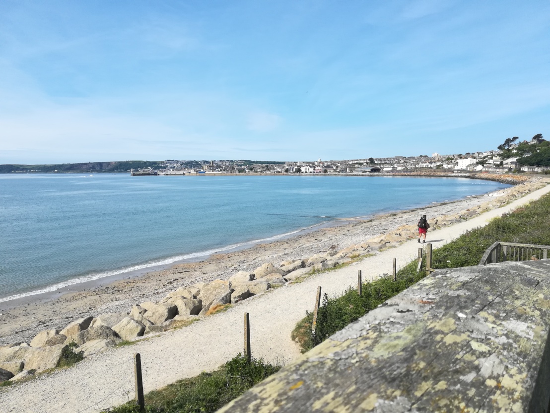
I take the tent down and allow the dew on it to dry in the midsummer’s day sun as I head uphill for a wash. It’s great to be up before anyone else on the site and breakfasting al fresco with sea views in early morning sunshine. I breathe it all in deeply, knowing I’ll be back at work tomorrow, tethered to a computer again after 18 days of being free range on the hoof (to cross-pollinate metaphors). I get away by 7.45 with just a slight limp, down past the clubhouse to the coast path, which immediately shows it means business by climbing up to the woods on High Peak.

Dazzling Ladram Bay
Dazzling Ladram Bay

In the woods I’m soon made aware, by the swarms of mosquitoes, that I’ve forgotten to apply sun  cream/insect repellent. Having had three nibbles from horse flies during this trip (have you noticed how they unerringly find a vein?), I quickly make good my omission. I then, so as not to blur my phone screen, wipe greasy fingers on my last remaining hanky, which I’m determined to hang on to for the remainder of the day.

The good old master plan allows nine hours for today’s walk. By inserting a rest day on Tuesday, I’m now due to finish on a day when Liz will be teaching in the evening, so she’ll only be able to drive out to pick me up if I’m on schedule; otherwise I’ll catch the splendid X53 for a scenic ride on a double decker along one of the best bus routes in the country. As I’ve found over the last couple of days, I’m pretty much fine going uphill, but my left shin slows me down considerably on steep downhills, putting a big question mark over my ability to get to Lyme for 5pm.

Another steep hill negotiated and I’m heading down to Sidmouth, when a detachment of squaddies in full kit and bearing arms come marching in step up the hill in two columns. I ask the first few whether this was a ‘beasting’, which draws a smile from some, then I ask their sergeant what they’ve done to deserve this and he says (loudly): “Nah! They bin good!” I dread to think what they get when they’re bad!

The first thing you come across on approaching Sidmouth from the west is a staircase known as ‘Jacob’s Ladder’.

Jacob's Ladder, Sidmouth
Jacob’s Ladder, Sidmouth

Now, everyone knows that the real Jacob’s Ladder is in Derbyshire and constitutes the soft way up Kinder Scout, now that the Pennine Way has been re-routed; this is a mere step-ladder in comparison. I look back at this morning’s route, less than 2½ miles, but it’s taken me an hour.

View west from below Jacob's Ladder
The first hour’s walk

I fail to find an open café along the seafront so ask a fishmonger, who’s just opening up his shop, and am directed to the Dukes Inn. There I indulge in my last full English for a good while, at the cost of over half an hour, but thinking that, if ever I needed to fuel up well, today’s that day.

Sidmouth Esplanade
Sidmouth Esplanade

Without further ado the coast path takes me over a footbridge and up Salcombe Hill Cliff, initially via steep side roads. Then it’s a switchback to the top of Higher Dunscombe Cliff which is, true to its name, higher. In the other direction, Portland beckons tantalisingly.

View west from Higher Dunscombe Cliff

By 11 o’clock I’m toiling up the sixth major ascent of the day, pausing for breath and mentally calculating that a 5pm finish is looking less and less likely, unless I really motor along any level sections but, if I do that, I’m likely to cause more issues with my leg. I text Liz again, because she keeps asking me to keep her posted on my ETA. By now, water has become a significant issue due to the sun, the heat and all the climbs – I’m likely to run out before I want to unless I can refill.

The next major descent causes a major problem. Many of these hills have thick, two foot wooden planks laid upright across the path as steps, intended to help walkers, but they’re a mixed blessing; sometimes the earth gets eroded behind the steps, so you have to choose between stepping, with your foot sideways, between these obstacles or balancing a foot precariously on the thin edge of the plank. Anyway, the steps are so deep that using them puts a strain on the knees, inducing walkers, where possible, to set foot to the side of them, creating stepped indentations in the earth; this can help you to reduce the depth of each wooden step down by placing one foot on or between the wooden steps and the other on the earthen steps to the side. I’m in the process of doing precisely this on the precipitous drop down to Branscombe Mouth when I see that my right foot is about to step on a twig; I take it for granted that, under the weight of me plus backpack, the twig will snap or be crushed. What it actually does is roll a short distance, causing me to come down heavily on my left foot for balance, jarring my shin. It takes me an age to descend the rest of the way down to The Sea Shanty café, hobbling with very short steps, convinced that my walk is over. I just don’t see how I can carry on to do the last 10 miles – I’ll have to call Liz. Worthy effort and all that, 279 miles, nice try – but a failure, a loss of face nonetheless. What a pain!

I limp into the first door of the café to be told, a trifle smugly, that I can only buy a takeaway coffee that side, even though there’s a connecting doorway between this bar and the larger one serving the other side. Ok, so I make my way painfully round to the main part, order a flat white and a slice of Bakewell tart and take them outside to a sort of inner terrace with a water feature, and off which there are loo doors. I sit dejectedly sipping, refraining from contacting Liz, putting off the inevitable. Removing the boot and rolling down the sock, I see that the leg is a little swollen and blotchy around the ankle and up the shin; does that mean it’s a stress fracture? Such a shame when I’ve done half of today’s walk, and the toughest half at that, at not far off 2½ mph excluding breaks. I finish the cake, re-tie my boot, then drink up the remaining water in my ½ litre container with the idea of refilling it, if not at the water feature, then at the sink in the gents. Being a tad dehydrated, I visit the gents only a refill, but find a notice saying that it’s not drinking water. When I ask in the café, the waitress is happy to fill my bottle, and it’s on returning to my table that I notice the pain has eased somewhat. Whether it was the brief rest, the caffeine, raising the blood/sugar level or the rehydration that helped, or combination of all these, I’ve no idea, but faint hope blossoms. I look up at the daunting East Cliff and, telling myself that limping uphill is easier on the shin than down, figure that I might as well give it a go.

Branscombe Mouth
Branscombe Mouth and the offending descent

In fact the path doesn’t climb all the way up the cliff but veers off to follow a route lower down, initially between more garden sheds. I suppose it was inevitable that the path would eventually climb to the clifftop, but it does so only after Hooken Cliffs. Could this be the last big climb?

Hooken Cliffs
Hooken Cliffs

The transition from red cliffs to white, from Triassic to Jurassic, is well under way. My progress is less well under way, but I’m moving. From here the Dorset coast stretches before me, with the length of today’s walk thus far visible behind. I round the corner at Beer Head  with Seaton below and only a short stretch to Beer itself. I’ll have to set aside my rule about not drinking both at lunchtime and at night, if only to have a beer here. I ask the scouser landlord at The Anchor Inn what proportion of his sales he thinks are thanks to this whimsy, but he says he hasn’t thought of it that way before. It’s a well-kept pint, though, second only to the one enjoyed in Coverack.

Beer
Beer

Naturally the climb after Hooken Cliffs wasn’t the last – there’s another one out of Beer, but it soon puts me in Seaton, which makes me feel really quite close to my destination because I’ve previously done the undercliff walk here from Lyme Regis. I celebrate by sitting on a bench to finish off my snacks – the final cereal bar and an apple; I’ve already consumed the peanuts and jelly babies for help with the earlier humongous climbs today.

Beware of the ducks
Beware of the ducks

I see no ducks as I leave Seaton, but what I do see is yet another blessed hill up to and alongside the golf course. I have to concede that I’m tired now, but I’d always planned to bow out on a big day, just as I did with the Byrness to Kirk Yetholm stage over the Cheviots to complete the Pennine Way; it takes the sense of satisfaction to another level. I might even have to resort to a ProPlus and some Kendal Mint Cake to keep me going. In fact, reading the sign posted before the undercliff path, I may need a rescue party: it describes all manner of hazards, tells you there’s no escape on the landward side and that it can take 3½-4 hours to complete the 7 miles to Lyme Regis.

Undercliff path sign

As it’s already 3.30, I hope it doesn’t take that long as that would be cutting it fine for the last bus to Weymouth and leave me no time to eat, but I have texted Liz to say that I’m not going to make it for 5 o’clock.

In the event, it takes me 2½ hours, but it’s some of the hardest walking I’ve ever done. There are lots of little ups and downs, including the notoriously nasty, deep steps, there’s mud, even after a long dry spell, because so little light penetrates, there are rocky stretches but, worst of all, there are masses and masses of tree roots to negotiate. And it just goes on and on and on being difficult. And if you’ve already done a dozen of the hilliest miles on the coast, and if that’s at the end of 18 days of walking, and if, what’s more, you’re carrying a stress fracture, then it becomes extremely tiresome. Yes I do resort to a ProPlus tab, yes I do munch half a dozen squares of Kendal Mint Cake, and I also, finally, run out of isotonic and water. Emerging from the woods into the sunlight around 6pm feels like a cross between coming out of a matinée film into daylight and crawling from the desert down to an oasis – the relief is vast.

The first pint doesn’t last very long. I’ve been seeing a mirage of a huge pizza for the last five miles, so that’s what I order at the rather pleasant Pilot Boat, along with garlic bread and a side salad. And another beer. Checking Viewranger, I see that I’ve covered 21 miles today, not 19, which helps to explain how the last section came to seem interminable. Before I pay up and leave, I check the bus times Liz has texted me and realise I just might catch the earlier X51, leaving Lyme around a quarter to seven; it only goes as far as Dorchester, but then I could catch the number 10 back to Weymouth and still beat the later bus, getting dropped at a bus stop closer to home into the bargain. I set off up the hill, only to see the bus trundle past, but it’s just as well that it did – I’ve left my hat in the pub! Retrieving the hat, I also pick up a paper serviette to act as a temporary hanky, my final cotton one having gone the way of all the others, doubtless enriching Devon’s landscape.

The bus stop for the X53 is outside the Co-op in Lyme. The Co-op is opposite The Volunteer Inn. Need I say more? Sitting at a bus stop opposite a pub, and a traditional one at that, for 45 minutes is more temptation than a weary hiker can take, so I simply have to sample their wares. I’ve rarely had so euphoric and gloriously panoramic a bus journey as this one, sitting in the front seat on the top deck, trying hard not to doze off. As a bonus, the day’s dehydration means that, even after five pints of ale, the bladder only just begins to murmer by the end of the 1½ hour journey. And how wonderful it is, as the bus pulls away from the King’s Statue, to see Liz approaching in the car. All in all, a fine ending to an arduous, uncomfortable day, rounding off a superb 18 day hike I’d heartily recommend to anyone slightly fitter than me!

Previous | Next

SWCP Day 14 – Gara Rock to Stoke Fleming

SWCP Day 14 – Gara Rock to Stoke Fleming

Sadly we awake to weekend weather. I guess two weeks of virtually unbroken dry weather and mostly sunshine was way beyond my expectations anyway, so I can only shrug at a return to the norm.

On a more positive note, although there are 16½ miles and over 3,000 feet of ascent to do today, I’ll be doing it with a light load. Our hosts provide us promptly with ample nourishment in decorous surroundings, enabling us to set off early and get me back on the trail well before 9 o’clock. Liz drives off to see the places she’s been wanting to visit, leaving me to stride off into the mist and fine mizzle. I start off wearing the Montane wind jacket I usually take in my day pack, but it’s not enough keep out the rain, so I soon have to resort to the Llotse jacket.

The path from Gara Rock drops down around 300 yards to rejoin the coast path and, as I descend, I see a young woman consulting her phone below me. In normal circumstances I’d ask if she’s ok, but I don’t want a walking companion slowing me down today; the sooner I finish, the more quality time I get with my wife. As a gesture of goodwill, as she sets off walking again, I indicate to her with a smile that I’ll leave open the gate I’ve just passed through. Once again I have the impression that she’s trying to catch up with me, but I’m motoring along quite quickly in spite of the wet rocks, the narrow path and the cliff edges, so she has no chance. Before long, after Elender Cove, I turn round to see that she’s no longer in sight. At Prawle Point the Coastwatch Officer up in the lookout station returns the cheery wave I give to demonstrate that I’m doing fine in spite of the weather. I do less well over the next section, edging around farmland, where my feet quickly get wet in the long grass, making me wish I’d brought gaiters with me. I see a pretty miserable-looking backpacker coming around the field towards me but, probably because I’m only wearing a lightweight backpack, he doesn’t deem my “Come far?” worthy of a response. I know how he feels; I don’t enjoy my feet squelching in my boots and being damp from having stuck to the flimsy wind jacket too long, and keep looking up at the lowering cliffs wondering at what stage the next hairy climb will start.

After three hours the rain abates, the sea mist lifts and, approaching Start Point, I feel it’s safe to get my phone out of its waterproof cover for the first photo of the day.

Start Point
Start Point

The coast path crosses the craggy ridge  a few hundred yards before the lighthouse, opening up stunning views of Start Bay, taking in the rest of today’s walk and tomorrow’s as well.

Start Bay
Start Bay

There’s a young couple with a baby carrier heading uphill towards me as I take the shot, indicative of the fact that I’ve left the rocky, ovegrown. unforgiving part of today’s path and that, henceforth, particularly now that the weather’s improved, it’s going to be busy. As I continue down towards the lost village of Hallsands, I see a large group of teenagers being addressed by one of their teachers at some length and can’t believe it when she bids them set off when I’m within 20 yards of passing them at a rate of knots. From the small clearing they all amble off down a narrow defile with bushes on either side, making it really difficult for me to squeeze past each in turn. They all step aside amiably once they become aware that I’m not one of their party, but it’s hard work as they’re all preoccupied with chit-chat. At one point I hop up onto a narrow bank of earth about four inches wide to tightrope my way past a few of them, then barge through when the group is held up at a gate. I did have it in mind to stop for coffee at Beesands but figure that, if the school party doesn’t stop, I’ll only have to get past them all over again, so I keep going, accelerating to ensure I can afford the time for a quick coffee at Torcross before they catch up. Imagine my dismay, therefore, when, on arriving in Torcross, I find another large school group just finishing up at the outdoor tables and getting ready to leave. So be it, I need the caffeine.

In fact I needn’t have worried: there are a number of options for walking the long stretch across Slapton Sands, particularly at the point where the road has collapsed. The SWCP website tells you that, during the road closure, the path will move to the seaward side of the road, but I find that, at least initially, the path on the landward side is good and with less pedestrian traffic. Where it becomes hard work on soft sand, I change tack and climb back to the road. It’s along this long section that I start to notice a slight strain on the outside of my left shin, taking some of the pleasure out of the day’s walk, although at least my feet and the rest of me have pretty much dried out by now. The strain seems to be a recurrence of the one I got through racing up Pen-y-Ghent when walking the Pennine Way and which sorted itself after a day’s rest, so I’m not too worried by it.

As you move away from Slapton Sands at the Strete end, there’s a warning sign that part of the beach is used by naturists. I briefly contemplate becoming a naked rambler but, having reserved my alcohol allowance for the evening, manage to resist the notion. The route then, having lulled me into a relaxed state by its complete flatness, suddenly pulls a fast one and becomes a switchback again.

Looking back at Slapton Sands

I slow down, partly because Liz is in Dartmouth, wondering if she has time for a cream tea, but also through fatigue and the ailing left leg. And because the route twists and turns, requiring a little more accurate mapping than Viewranger or OS 1:25000 can provide. Opposite Blackpool Sands I find a fine pair of pheasant feathers on the path, a far more appropriate gift for the boys than a trio of golf balls, and lighter too. And less likely to upset the natives.

Blackpool Valley
Blackpool Valley

The day’s walk still isn’t done when I reach Stoke Fleming. I find myself opposite the Green Dragon, so naturally succumb to a palatable pint of its IPA offering, Seahorse, then investigate the onward route of the coast path as signposted alongside the pub. After an unedifying trawl round the back passages of the village, presumably necessitated by the fact that a walk up the narrow main street would be hazardous, I finally find our intended rendezvous and wait, wishing we’d set the pub as the meeting place.

Back at the b&b we ask our hosts for their recommendation for a local eatery, wondering if the Mexican joint we’d spotted the night before would be any good. They counsel against it, proposing a few other preferable alternatives, amongst which is The Fat Monkey. We’re so taken with the establishment that I ask if there’s any chance of them relocating to Weymouth. Alas, the answer is no, but that we’ll have to keep returning there. And do you know what? We will!

Previous | Next

SWCP Day 10 – Whitsand Bay Fort to Plymouth

SWCP Day 10 – Whitsand Bay Fort to Plymouth

Disentangling myself from my silk sheet sleeping bag, which always twists itself in the opposite direction to the sleeping bag itself,  and hefting myself off a stiff shoulder onto a stiff elbow, I reach for my watch, safely stashed in the tent’s mesh side pocket. What?? After 8 o’ clock? That’s crazy! I don’t sleep in this late in a comfortable bed, either at home or in b&bs or hostels, let alone on such hard ground in a tent. I guess I must have been pretty tired yesterday. Well, if you’re going to get a late start, do it on a day when you have only 10 miles to walk and less than 2,000 feet of ascent, I suppose.

It seems the height of luxury to have a picnic table on which to set up my Jetboil and eat my muesli, under clear blue skies again, what’s more. It’s a spartan breakfast by recent standards, but I figure that a couple of cereal bars during the walk will suffice to see me over to Plymouth, where there’ll be myriad opportunities for stuffing down the calories. I have to admit that I’m getting a rosy view of this camping lark, being able to pack everything away dry each day. My main concern about the weather is that, if this is such a good summer, the sort you get every dozen years or so if you’re lucky, then next year, when I do LEJOG, it’s bound to be piss-awful. Oh well, I’ll worry about that when the time comes – right now it’s awesome.

I don’t know about you, but I like to be consistent with where I stash things so that I can find them easily. I don’t think I’m obsessive, but in comparison with my family, who all seem happy to leave things where they are when they’ve finished using them so they’re never in the same place twice, I have a tinge of OCD. Putting things back where they belong may be boring, but it makes life easier and occupies less brain-space. That’s why I always keep my hanky in the left pocket of my shorts, along with my Swiss army penknife. Since I use the knife infrequently, just for cutting up moleskin before I don socks at the start of the day and sometimes for its toothpick after a meal, I think it’s better placed in that one rather than in the right pocket with my loose change, where it’s more likely to become dislodged when I rummage for money. The pockets both have zips so, in theory, the hanky should be lodged securely in there, incapable of escape. I confess, though, that I don’t always remember to fasten up the zips, and I’ve even caught myself bunging my phone in the left pocket for convenience instead of back in the pouch on my rucksack’s belt. I make a decision to impose strictly the policy of not using the pocket for the phone and of remembering to fasten the zip for the rest of the week, until Liz can come to the rescue again with more hankies. I spend the rest of the week patting my left hip to check that my one remaining hanky is still there.

So, all packed up and ready to set off without a stick, I make my way down to reception, where I catch the lance corporal scoffing breakfast behind her counter. Wishing her bon appetit, I ask if there’s a pedestrian exit to save me having to stoop under the barrier with my backpack on. Reluctantly, as she’ll be deprived the opportunity to exercise her barrier-power again, she directs me to an obscure gate and path. I find my way out of the fort soon after 9.30, noting that there’s no sign to indicate access to the campsite at this point, so it’s hardly surprising that I walked past it yesterday.

Rame Point
Rame Point

Heading for Rame Point, navigation isn’t straightforward because the route passes through the continuing warren of cliffside garden sheds, each with its own path. Prince Charles has a lot to answer for, if they’re on his estate.

In front of me is a lady with a small backpack, making fairly good progress. As I catch her up at a fork in the paths she stops, ostensibly to check her map, but more likely to let me pass and get ahead. She tells me she’s caught a bus from Plymouth and is walking to Rame Head, then on to Cawsand to catch another bus back to town. I wish her well, then forge on.

Looking back from Rame

Turning the corner at Rame gives fine views back over this morning’s and yesterday afternoon’s route.  Emerging onto the common, I see a number of dog walkers and family groups out enjoying the fine weather and views. My next decision is: should I make a slight diversion to climb up to the chapel?

Rame Chapel
Rame Chapel

Had today been more of a challenge I’d probably decline the additional ascent, but hey! It’s an easy day!

Back down from the viewpoint and carrying on round Rame Head I encounter an obstacle I haven’t seen before.

That’s to say, I’ve seen plenty of ponies and even passed quite close to some of them, but I haven’t had one standing right in my path before. He’s between a cliff and a steep place, so I expect him to turn and trot along the path until he can divert off to the side as sheep and even birds tend to do in their various ways, but no, this one’s staying put. Bearing in mind that he’s not a domesticated animal I take the precaution of removing my rucksack and keep it between, firstly, his teeth and me and, secondly, his hind hooves and me. Foolishly, as I sidle cautiously alongside him, I give him a stroke, at which he flinches; “Ok mate, don’t worry, I won’t hurt you if you don’t hurt me.”

Looking back at Rame Head

By the time I reach Cawsand it’s approaching midday and coffee time, so I’m interested when I see a handwritten poster advertising coffee. I soon twig that it’s a church group, but I’m not fussy – caffeine’s caffeine, after all. I’m just peering down the steps to check that I’m not being enticed into a dungeon when an elderly lady appears, startled to see a strange figure in shorts and sunhat, but able to recover her equanimity at my smile sufficiently to encourage me to go down. “Make haste, they close in ten minutes!” It turns out that this is a weekly event, scheduled on Tuesday because that’s the day the local café used to close and carrying on by popular demand even though the café now opens every day. There are just three people left when I get there, two ladies of a certain age and a young man with a central European accent. The coffee’s free but donations are invited, so I make one and beg a chocolate digestive biscuit. One lady and the young chap make their excuses and depart, leaving the leading lady to tell me all about the group. Apparently its main function has become to provide a social event for visiting Austrians and Hungarians, with whom there’s a sort of exchange agreement, so that groups visit every year. This is the Congregationalist Church organising the event, but she makes no effort to query my beliefs or to proselytise in any way, so it’s been a relatively quick, cheap coffee in pleasant, informative company.

Cawsand is confusingly close to Kingsand, so that you can’t tell them apart as you walk through, but I bet there’s intense local rivalry,  as much between the two counties as between themselves, this close to the Devon border.

Kingsand
Kingsand

Approaching the ferry, I pass through the grounds of Mount Edgcumbe House and Garden, including the formal gardens and orangery tea rooms. It’s all very elegant, ideal for ladies that lunch and genteel retired folks and it’s certainly worthy of a photo or two, but in the first place I feel slightly out of place with a large rucksack on my back and, secondly, the ferry goes every half hour and if I don’t hurry I’ll miss the 1.30 crossing.

What is it about towns? The only place I’ve had any rain in ten days has been Falmouth, where there was a brief spell of drizzle and now, crossing the Tamar, the clouds are once again gathering. But that’s ok, I don’t have far to walk and there’ll be ample scope for taking shelter.

Plymouth
Plymouth

Making extensive use of Viewranger I navigate the city streets and find the so-called Backpacker’s Hotel in a seedy, run-down quarter, with decaying cinemas and theatres, dodgy shops and many sad specimens of humanity.

Empty Plymouth theatre

Inside the hotel, where the first impression is of fraying carpets and third-hand furniture, there’s a sort of conciergerie/reception occupied by a large person who, it transpires, seems to be female. She checks my booking, £25 payment and ID, then confesses she’s been unable to get back the key for the self-contained flat I’ve booked; I can either wait in the lounge area and make myself a coffee while she chases it up, or take a dorm bed instead. Not feeling confident in her ability to chase anything, I opt for the dorm and make myself a coffee anyway. I assume the two middle-aged guys hanging around are guests, although they don’t look like backpackers, more like part of the furniture. The patronne emerges from her den and offers to refund me £10 if I give her my bank card, but I say I’ve recently replaced the one I paid her with, so cash would be appreciated. She agrees, stumps up the tenner then advises me that the shower on the first floor doesn’t work very well so I’d do better to use the one on the next floor up. I rinse my mug and head upstairs.

Dubious though the accommodation is, it works out well. I’m the sole occupant of a four bed room and a clean towel, albeit a rather aged one, has been laid out on each bed, giving ample scope for my clothes-drying trick. I duly set off for the shower with both sets of hiking clothes and my evening attire and re-emerge, half an hour later, showered, changed and with freshly washed and wrung clothes. I leave them drying as I head for town, wearing my waterproof jacket for the first time; it’s as well that I do because, before I’ve walked half a mile, the heavens open. A dramatic rainstorm has people in their summer clothes diving for whatever shelter they can find, whereas I carry on regardless. I’m looking for a Thai eatery I found on Tripadvisor and for which I printed a small map but, foolishly, left it in the hotel. I think I can roughly remember the way, but I can’t really – the only one I can find isn’t open until the evening, so I end up walking miles, kind of defeating the object of including a semi-rest day with less walking. In the end I opt for a mid-afternoon goat stew in Turtle Bay, with a rather refreshing limeade. By the time I leave the restaurant, patting my hip to check the hanky’s still there, the heavy rain has given way to a few large spots, which serve to remind me that I’ve left my hat inside. Doh!

The snag with backpacking, or maybe the advantage, is that you’re aiming to travel light and therefore you really don’t want to do much, if any, shopping, so I wander round aimlessly, then back to the hotel for a rest. Rest? That’s a laugh! A party of 9 year-old French schoolchildren have returned to this, their accommodation, after a day trip and, presumably having been cooped up in a coach, are now flying around the building like subatomic particles at CERN. Like the Backpackers Lodge in Falmouth, there’s the offer of toast in the morning, but I ask madame where  a hungry man might get a full English. She recommends two places, one a hundred yards or so up the road, opposite Aldi, the other being Wetherspoons, which I’ve already passed twice. Considering it prudent to check out the ‘Spoons offer, I head back down there. It’s very busy, and takes an age to get served and, even then, Abbot Ale is off; I’m mighty sceptical when the barman suggests something called ‘Devon Dumpling’ as being a similar type of ale, but give him the benefit of the doubt. In fact it turns out to be the best beer I discover on the whole trip, in spite of its name, as confirmed by the second pint.

I had expected that, after an easier day, the goat stew mid-afternoon supplemented by the day’s remaining rations in the evening would satisfy my appetite, but the combination of well-hopped ale and a careful reading of the breakfast menu at ‘Spoons has put paid to that idea. On the way up to check the café’s breakfast offering I stop at a Polish shop and buy some sausage and a bread roll. Having inspected the menu oppsite Aldi, I decide that the refillable coffee mug at ‘Spoons swings the decision in their favour, then pop into Aldi for all manner of stuff, purportedly to take as a packed lunch tomorrow, but in reality also as a naughty supper tonight – complete with three bottles of beer. That’s me well and truly off my two-pint wagon. One of the bottles I bought merely for its cheek:

North Bridge Brown Ale

I suppose if the Chinese can do it, why shouldn’t the Irish?

Previous | Next


SWCP Day Two – Penzance to Porthleven

SWCP Day Two – Penzance to Porthleven

I’m so glad I picked up the tip, from Walking Forum, about including ear plugs in the packing list; there were three of us in a dormitory for six, at least one of whom was a snorer. Of course, after five pints of ale the previous evening, there’s every chance that I joined in with two-part harmony, but I have no way of knowing. Here’s another tip: if you’re in a hotel/pub/b&b/hostel with motion detector lighting in the loo, and if you should need to pay a visit during the night and, moreover, if you should happen to drift off to sleep whilst seated in there, don’t panic when you wake up in the dark with no memory of where you are – just wave your arms about, preferably without screaming. Waking up in the night does, though, have the advantage of providing the opportunity to take your phone off charge, assuming it’s reached 100%.

Awake before 7am when the earliest breakfast isn’t available until 8, I retrieve my washed kit from the drying room and re-pack. The most time-intensive part of getting ready is pre-emptive treatment of the feet – foam tube for the overlapping toe, moleskin padding on a spot that felt warm yesterday and a Compeed plaster for the painless blister that’s developed over hard skin on the inside of a heel pad. I try always to pay heed to the ‘Treat your feet like royalty’ admonition I found in someone’s account of their Pennine Way journey. Then, of course, there’s the factor 30 sun cream, used as much for its insect-repellent properties as for its UV protection. Finally ready for the day, I head downstairs at 7.45 complete with Backpack, anticipating that I’ll be able to set upon the cold buffet elements of the breakfast offering before the full English becomes available but, incomprehensibly, the dining room door is locked and remains so, resolutely, until 8. Oh well, with 15 miles to do again today, there’s no particular time pressure today, particularly since there’s less than 2,000 feet of ascent. Chatting with another impatient hosteller, a somewhat rotund American engaged upon walking a few modest stretches of the coast path, I repeat my story: that I was going to do the whole SWCP next year as a retirement project but thought that Land’s End to John o’Groats would be more fun, so am doing Land’s End to Lyme Regis this year as a practice. Since there’s time to spare, I add that I’m carrying camping and cooking gear this year specifically to make my pack lighter, hoping thereby to boost morale next year.

Maxed out with calories, I set out well before 9am under blue skies and head back down to the coast path. I miss the path on the way out of town and follow the road for half a mile before rejoining it by crossing a pedestrian bridge over the railway. This is to become something of a theme in towns, where local ‘premier’ attractions are well signposted but the South West Coast Path is relegated to the obscurity of division two, leaving you to guess.

Looking back at Penzance

I stop for coffee at a shack run by a surfer-dude; on his hut are two large signs, the one on the left with an arrow pointing along the path towards his business rivals saying ‘Normal coffee’, the other pointing to his serving hatch saying ‘Life-changing coffee’. I approach and say that, without wishing to appear smug, I’m ok with my life and could he therefore dish up a cup of normal stuff? He seems to be ok with his life too and, on a day like this, who wouldn’t be, in that spot?

The views are dominated by St Michael’s mount, as they have been since the middle of yesterday afternoon. As I approach, a trio of what I assume to be Godolphin horses are being led into the sea for their water-therapy. One of them rears up at the waves, but is soon coaxed in.

Horses bathing
Horse therapy

The hard surfaces soon have my walking stick clicking on the ground with a familiar sound; turning it upside down to examine it, I find that the metal has again pierced the new rubber tip – so that’s why they sell you four!

On my way round the bay, I’m soon tempted onto the beach to join the morning strollers and, approaching Marazion, find that I have to coax myself into the water to cross a stream. This is time-consuming, because I have to remove carefully my boots, socks and foam tube, then wait for my feet to dry in order to remove sand before replacing them. The moleskin pad fails to adhere after its wetting, so I rub on a smear of anti-blister stick instead. It’s gone 11 o’ clock before I’m finally leaving the townscape.

St Michael's Mount
St Michael’s Mount

Coming in the opposite direction along the path are so many Germans today that, eventually, I stop saying ‘Good morning’ or ‘Hi’ and start greeting fellow walkers with ‘Guten Tag’ instead. The farther I go, the fewer I see but, even so, the sun has certainly brought out the fair-weather ramblers in force.

After a leisurely lunch of the YHA packed variety, including a liquid KitKat, which I should have eaten before setting out to avoid having to spend ages extricating the biscuit from its foil wrapper, I carry on through prime smuggling and wrecking territory. The path passes through the courtyard of the fascinating Arts & Crafts-style Porth-en-Alls House, built on land once owned by the notorious smuggler John Carter, aka ‘King of Prussia’, hence the name Prussia Cove for the location.

Porth-en-Alls
Porth-en-Alls

There are plenty of folks enjoying the weather at Praa Sands, but I’m only interested in coffee. I tell my story to the girl serving at the café’s hatch, in response to which she insists I call again when doing LEJOG for charity so that they can donate. Once again I miss the path off the beach and head up a steep road instead, opting to make my way back to the coast via footpaths shown on the OS maps on Viewranger. The paths on the ground aren’t as clear as they appear on my phone, so I plod forlornly looking for an exit around a couple of fields before re-tracing my steps back to the first field and climbing over what was probably once a viable stile but now requires the removal of the rucksack to surmount. The way back to the coast path soon becomes clear however and, before long, I’m savouring the full flavour of the SWCP, hauling myself up and down roller-coaster hills to pay for the level ease of this morning’s route. At least, by now, a few thin clouds have rolled in to cool things down a little. At the risk of becoming hackneyed, I stop to take a shot of an old engine house, if only as a tribute to Wycliffe:

Mine engine shed
Engine shed

Yesterday in the Admiral Benbow, I overheard a lady on the adjacent table saying that, when Googling Porthleven, she’d read that it’s the most storm-battered village in the country; today, bathed in tranquil afternoon sunlight, such drama is hard to imagine.

Porthleven harbour
Porthleven harbour

I quench my thirst at a harbourside hostelry, then head for ‘Out of the Blue’, the name of the pub to which tonight’s campsite belongs. The name, I learn from the jovial manager, derives from the famous Blue Anchor at Helston, whose owners bought this pub as an additional outlet for their beers. I tell him, and the others at the bar, about the time when, back in the 1970’s, the Blue Anchor was one of just three home-brew pubs in the country, the others being the John Thompson Inn at Ingleby, south of Derby, and the Three Tuns at Bishop’s Castle in Shropshire, and how I’d made it my life’s mission to visit all three. As the day wore on into evening, I bored them with the story of how, when a relative and her husband bought a pub, they’d asked me if I’d set up a micro-brewery with them, and how’d I’d spent weeks looking into it, spending a day in three different small breweries including the John Thompson Inn and working through the finances. In the end I’d decided that, with three young children at the time, it would be too great a risk, because its viability would depend on selling beer to surrounding pubs and hotels, many of which were tied, either by ownership or by loans, to the big breweries and therefore obliged to sell their beer. Wimping out of that opportunity had been a big shucks, but it had probably saved my liver and my life.

I pitched my Snugpak Ionosphere for the third time, but this was for real, with a view to getting my first night’s sleep in it. I strolled back into town for food from the supermarket and, feeling duty-bound out of deference to the mining tradition, succumbed to one of their warm pasties. Back at the pub, I found framed photos of old Porthleven all around the walls, many providing evidence that this is indeed the country’s storm centre.

Storm-lashed Porthleven

I also learn that Monday night is folk night, so continue to abuse my liver with more of the famous Spingo ale. In the event there are more musicians than audience, but I enjoy hearing them perform for each other. In spite of the entertainment, around 9pm I take pity on my liver and stagger off to the tent, pitched ignominiously next to a swish campervan, and endeavour to get comfortable enough to sleep. Eventually I do, even though I can’t quite figure out what to do with the arm which, between me and the hard ground, seems surplus to requirements.

Previous Next

Countdown to the SWCP

So, here I am just five weeks from travelling to Land’s End for a 287-mile walk back to Dorset; it’s time to review my fitness levels and plan what else I need to do before I set off. I’ve done half a dozen walks, including ones of 18 and 12 miles respectively on consecutive days (twice), all with around 13 kilos on my back. My feet, after a few applications of meths, have withstood the test pretty well, apart from an area on my left foot which blistered, but which has now healed ok. Last weekend I pushed my average pace up over 3mph and included a fair bit of arduous ascent on another 18-miler; only my hips were still complaining the following day. Today I’ll do the 26 mile Dorset Downs circular or perhaps, more descriptively, a ‘squarea’ from Cerne Abbas, the one I’ve done each of the last three years, so that now it seems to have become almost an annual ritual.

Cerne Abbas giant
Cerne Abbas giant

One thing it isn’t – a fertility rite; with five sons and five grandchildren to date and having opted for the snip three years ago, my fertile days are behind me, or perhaps they’ve fled over the giant’s hill. When looking for a challenge of marathon proportions I discovered this walk on the ViewRanger app, a freebie, and found it to be, for most of its length, an enjoyable if testing tour around central Dorset. There are fine, memorable views, firstly back down the Cerne valley, then westwards from the Wessex Ridgeway over the Sydling Water valley, south over Dorchester and Puddletown, a full 360 degree panorama from the approach to Nettlecombe Tout, southwards down the Piddle Valley above Alton Pancras, before rising over the final ridge and back down beneath the giant. The only drawback is the lack of a pub anywhere on the route until the return to Cerne Abbas, but there’s ample compensation here, with two fine village hostelries offering not only the opportunity for rapid re-hydration but good pub grub too. When spring comes around each year, I walk to work each day down The Grove in Dorchester looking yearningly out over the fields ahead north of Charminster, between which runs the southern side of my square walkathon, a track along Waterston Ridge, and I long to get out there; each year I succumb to the urge a little earlier .

Until last weekend the footpaths have been, for the most part, unspeakably muddy, so that I begin to look forward to the day, maybe a couple of years hence, when I can forget about all this semi-rigorous training and become a fair weather walker again. Late April has, at last, brought a short spell of dry weather, allowing many of the slushily fluid, hoof-trampled and bike tyre-rutted stretches to drain down to a more easily navigable, smoother, boot-trodden stickiness. Last night’s heavy rain coupled with today’s cool, cloudy conditions have left slightly slithery surfaces again in parts and a lot of very wet grass, prompting me to stow gaiters in my pack. The backpack itself is just a day bag, a 22 litre Osprey Talon rather than the full 13Kg Bergans complete with camping gear, because today’s walk is 5 miles longer than any single day on this year’s SWCP effort and, with just over 3,000 feet of ascent, will provide enough of a test without the additional weight. I’ll also take a day pack for my 24½ mile walk to Corscombe next weekend, but then it’ll be back to the grind with a full pack for a 21-miler from home to Portland Bill and back, and for the final grueller, the 20-miler with 4,000 feet of ascent between Lulworth and Swanage. My hope is that, having done a serious stretch of the SWCP with camping gear this year, when it comes to next year I’ll see LEJOG as an altogether ‘easier’ proposition with no camping gear to carry for most of the way. Mental preparation or brainwashing? I don’t care, as long as it works!

Here I go then, setting off from the car park just below the giant at 8:20, remembering to turn on GPS and ViewRanger on my phone. I’ve estimated 9 hours for the walk, which I’ve modified slightly this year, firstly in an attempt to avoid an unpleasant stretch on the eastern arm and, secondly, to head straight back to the car avoiding the pubs. What?? A tough call, I know, but, as Liz isn’t able to join me here for a meal this evening, we’ve planned a steak meal at home instead. Until then I have just an apple, a couple of cereal bars and a rollmop and beetroot sandwich – my favourite for long hikes. Oh, and some salted peanuts and two jelly babies as emergency rations. Not forgetting the hydration – 1.5 litres of water in the Camelbak reservoir, a 600ml flask of water with a Zero electrolyte tablet added and, finally, a ProPlus tab to avert caffeine withdrawal symptoms; not for nothing was I in cub scouts – the lesson to ‘be prepared’ was well absorbed.

Through the thin strip of woodland below the giant, down through 200 yards of wet grass, overtaking a couple of wellie-clad dog walkers expressing a tone of surprise, whether at the sight of a hiker out this early or of one wearing shorts in such cool, damp weather, I can’t say. They’re dawdling along well behind me when I turn right onto a ‘Private’ track towards Minterne Parva, not too worried that they might be the landowners; it’s a clear enough track that I’ve ended up using twice before after struggling to find an alternative path through the woods that lie alongside it and, after all, a lone walker isn’t likely to do any damage.

Spring is certainly doing its thing: primroses, bluebells, coyly furled dandelions, trees caught in the act of donning their summer clothes, May blossom, vibrant gold gorse and fluorescent rape fields circumscribe my march through nature’s gallery with insistent daubs, dabs, dots and smears of colour. Fauna too – I interrupt the ruminations of, in turn, a rabbit, a hare, a squirrel and a trio of roe deer, all of whom scamper away prudently or, in the case of the hare, madly. Rising to meet the Wessex Ridgeway, I see a trio of hikers ahead, evidently aiming for the same point on the ridge but having climbed via the more direct path from Cerne. One of the two ladies stops to re-tie a bootlace as I approach, bringing forward the point at which I overtake them and enabling the exchange of a few words. They agree that this is, indeed, a fine stretch with views over Sydling, and let me know that they’re doing a walk of around 10 miles. I refrain from telling them of my planned route, not wishing to demean their worthy enterprise, but bid them a good day and proceed apace. Over the next mile or two I glance back as I pass through gates and see they’re not too far behind, which makes me think they’ve accelerated to see if they can keep up with the older man who’s just passed them, but all that’ll achieve is to abbreviate their pleasant walk; they’ll be back in Cerne too early for lunch if they’re not careful.

There are magpies around today (salute for one, two for joy) and, as the cloud-filtered light generates a modicum of heat from the hillside, a buzzard struggles to gain altitude. Everywhere there are pheasants, the males of which species seem almost prehistoric in their ungainliness, to the extent that their survival into yet another century seems miraculous. Until you remember that some men like to play with them, so they’ve been conserved as toys for the idle. When you consider that wolves were hunted to extinction in England by the 16th century, it’s clear that they missed a survival trick that pheasants, dumb as they seem, latched onto. Perhaps if wolves had offered to humans an occasional sacrificial victim, with culinary advice along the lines that the beast should be spit-roasted for half a day and served with redcurrant sauce, men might have learned to see them as a resource rather than a threat.

Half way round the walk there’s an old cattle truck parked in a small clearing by the track and obviously being used as a caravan. It’s been there for at least three years and has even had some conservation work done on it in that time, with varnish applied to the woodwork and tarpaulins wrapped around the wheels and the cab. I’ve never seen the occupant before today but, as I approach, there’s a guy standing on the path alongside the truck. By the time I reach the spot he’s vanished, presumably into the calm isolation of his remote abode, so I don’t have the opportunity to ask him the question I’ve had ready for him each time I pass by: “What do you do for fresh water out here?”

Less than a mile on there’s a delightful spot set into the hedgerow, with two double benches, a fruit tree between and flowering plants around them, overlooking Waterston Manor and the Piddle Valley. I’m not sure if it’s been set here as a memorial of some sort, but I do know it’s a perfect location in which to take a bite of lunch and, if necessary, tend to your weary feet. As usual, I start my packed lunch with the apple and have just set about consuming the sandwich when a family of four approach, heading west along the track. The amiable father seeks my advice on finding a way back to Dorchester; they’ve set out along Hardy’s Way from Hardy’s Cottage but seem to have taken a wrong turning somewhere. His wife doesn’t look at all gruntled with the situation – in fact her sour expression tells me she’d sooner be anywhere but here at this precise moment. I ask if they have a map or GPS device, to which the chap responds by waving a walk leaflet. Not being sure where the Hardy Way runs, I try to reassure them that, if they carry on to the first road they meet and turn left, they’ll reach Dorchester. The wife doesn’t look remotely reassured, so I try to cheer them up by telling them it’s a great path with lovely views, neglecting to mention the very slushy bit where the farmer has tried to improve the track by laying down something like gypsum. This may have succeeded in filling most of the puddles along that stretch, but it’s just made the mud very sticky and dazzlingly white. I hope their footwear’s up to it.

After a 10 minute lunch and a couple more spent removing a stone from inside a boot, it’s not long before I find out why the good lady was so unhappy: the track continues as Gaddy’s Lane, where the farmer has left piles of gypsum but has yet to spread them over the mud and puddles. Instead, his tractor has churned the ground into a horrible mess across the entire width of the track and, in seeking a shallow route through it all, my boots sink ankle deep and nearly remain in the sucking mire. What with that and the horse flies hovering around, the only surprise is that the pater familias managed to remain so chirpy in the face of the adversity.

For me the only irritation is that I’ll have to clean my boots. That’s why, when I find that my first re-routed section takes me through long, wet grass, it proves to be a mixed blessing – ok, my boots get so wet that patches of dampness seep through the GoreTex lining, but most of the mud is removed. The gaiters stay in my pack.

Back at the car I check ViewRanger:  41.5 km, 25.78 miles, with 3,008 ft of ascent at an average rate of over 3 mph even including  stops, 8 hours 20 minutes all told and home in time for tea. That’ll do for me. No blisters, no strains and only slightly achey hips. I reckon all that merits a beer, even if not at the pub, to celebrate being on track.

Previous |

A Planning Marathon – Land’s End to John o’Groats

The longer your journey, the more choices you have over the route to take. Once you’ve taken the crazy decision to walk end-to-end across the British weather map, you then have to work out your criteria for deciding which way to go. The first dilemma, clearly, is whether to start from Land’s End (LEJOG) or from John o’Groats (JOGLE). Just as when I did the Pennine Way, having the prevailing winds and the sun behind you seems to make sense, but there’s also the argument that, walking north, you keep pace with the advancing season as opposed to walking from cooler to hotter weather. Another advantage is that Cornwall, in early June, will be relatively grockle-(or emmet-)free, whereas in August it’ll be teeming and make accommodation more problematic. Finally, I started this whole thing with walking the South West Coast Path as a retirement project, until that was subsumed under the greater ambition to do LEJOG, so I’m strongly motivated to begin the venture by completing the SWCP.

There are numerous books and websites you can consult to help with your choice of route. A good place to start is Martin Hockey’s website, not for the eccentric route he took via his home town, Oxford, but for his list of routes taken by other end-to-enders. My own deliberations can bypass the question of whether to cross Cornwall and Devon north, south or central because the SWCP will take me all the way to Minehead. Based on my own dubious experiences and having read John Hillaby’s ‘Journey Through Britain’, I’m happy to miss out Dartmoor in favour of the coastal option, even though it’s longer and includes more ascent and descent; I’ll rely on the hope of getting fitter as you proceed to help me cope with those days on which I’ll have to climb the equivalent of Ben Nevis, as well as cover 15 miles or so – for example around Boscastle, Bude and Lynton. From Minehead, the choices start to open up again, forcing me to ask myself what I want out of the walk aside from the achievement: do I want to take the shortest route, are there particular places of interest I want to visit, would I like to call in on friends or family en route? According to Google Maps, you can complete LEJOG by following a walking route, albeit mostly on roads, over just 811 miles but, in response to my first question, no I don’t want to take the shortest route; I’d much rather take scenic paths, avoiding roads where possible. My interest in architecture, geology and archaeology, industrial or otherwise, are such that I’ll imbibe information about features I chance upon, but won’t make detours to incorporate them. As for imposing myself, in my muddiest or dustiest, sweatiest manifestation, on anyone whose friendship I value, I’d hesitate to accept an invitation, let alone base my strategy on making such visits. No, my main criterion will be to follow well-trodden, waymarked trails wherever possible. I’ve long been inclined to sample the delights of Offa’s Dyke so, from Minehead, I’ll head for the original Severn Bridge and the Welsh border. A section of the English Coast Path has recently been opened between Minehead and Brean Down, so the route round to Weston-Super-Mare should be relatively straightforward. I’ll branch off the Dyke to follow the Llangollen and Shropshire Union Canals as far as Middlewich, from where the Peak District is just a two-day stretch. At this point I may encroach upon the hospitality of family on the outskirts of Sheffield for a day of rest before tackling the Pennine Way again. Trails are never the same twice, because of the inevitable variability of the weather, the time of year, the people you meet, the places you stay and the changes that have been made to the path itself. I won’t adhere religiously to the Way but will gladly subordinate it to the over-arching goal of LEJOG by, for example, proceeding directly to Alston from Middleton-in-Teesdale if the weather is the least bit iffy. I’ve done Cauldron Snout, I’ve seen High Cup Nick both with and without the view, and I’ve no great urge to mount Cross Fell for a third time. I’ll also head for Haltwhistle rather than Greenhead, and dip down off the Cheviots to Jedburgh. My aim will be to complete the Pennine Way section in 13 days plus a rest day this time, as opposed to 17+1 last time. I was initially tempted to seek an alternative route, particularly after the Yorkshire Dales, with a view to finding a less boggy route, possibly via the Howgills, but eventually opted for the known devil!

From the Pennine Way to Inverness I’ve allowed myself to borrow heavily from Mark Moxon, whose excellent website contains a goldmine of information as well as an entertaining journal of his progress; I just hope my feet shape up better than his did! Liz wants to do the West Highland Way, in spite of my warnings about midges and horseflies in late July, and the need to meet up with her and the boys in Milngavie after the start of the school holidays provides the pivotal date around which the entire escapade is designed. Beyond Inverness lies the budding John o’Groats Trail, which aims to provide a coastal alternative to the unattractive slog along the main road; I hope it’s nearer to completion by next year, when I’ll certainly want to give it a try. Acknowledging that it’ll be more challenging as well as more rewarding than marching up the A9, I’ve added an extra night in Lybster to my original plan. So, having now drawn out my route on ViewRanger and saved the gpx files for each day, I have 75 walking days in which to cover over 1,260 miles, at the rate of nearly 17 miles per day and with an average daily ascent of 2,120 feet.

Here it is then, the master plan:

Stage From To Miles Ascent
1 Land’s End Treen 15.2 2671
2 Treen Hayle 13 2122
3 Hayle Porthtowan 15 2595
4 Chapel Porth Newquay 18.5 3311
5 Newquay Treyarnon 13 2301
6 Treyarnon Port Quin 18 1802
7 Port Quin Boscastle 15.75 4189
8 Boscastle Widemouth Bay 13.5 4000
9 Widemouth Bay Bude 3.5 500
10 Bude Hartland Quay 15.5 4304
11 Hartland Quay Buck’s Mills 13.75 3843
12 Buck’s Mills Bideford 14.5 1824
13 Bideford Croyde 22.5 1025
14 Croyde Combe Martin 17 3271
15 Combe Martin Lynton 14 4051
16 Lynton Porlock 12.75 3794
17 Porlock Watchet 15.75 1966
18 Watchet Combwich 15 1138
19 Combwich Brean 22.75 612
Rest
20 Brean Clevedon 20.5 672
21 Clevedon Aust 21 911
22 Aust Brockweir 12 1833
23 Brockweir Monmouth 11 1977
24 Monmouth Pandy 16.75 1912
25 Pandy Hay-on-Wye 16 2335
Rest
26 Hay-on-Wye Kington 15 2242
27 Kington Knighton 13.75 2548
28 Knighton Mellington 14.25 3434
29 Mellington Llanymynech 23.5 1873
30 Llanymynech Chirk/Waun 16 2738
31 Chirk Whitchurch 24.5 755
Rest
32 Whitchurch Middlewich 25 444
33 Middlewich Congleton 16.5 867
34 Congleton Buxton 20 2882
35 Buxton Edale 16.5 2330
Rest
36 Edale Crowden 16 2995
37 Crowden Light Hazzles 19.5 3218
38 Light Hazzles Ponden 17.5 2313
39 Ponden Malham 23 3158
40 Malham Horton 15 2660
41 Horton Hawes 14 1759
Rest
42 Hawes Tan Hill Inn 16 3005
43 Tan Hill Inn Middleton-in-Teesdale 17 1614
44 Middleton-in-Teesdale Garrigill 19
45 Garrigill Halwhistle 17.5 557
46 Halwhistle Bellingham 20 2317
47 Bellingham Byrness 15 1814
48 Byrness Jedburgh 21 2686
Rest
49 Jedburgh Melrose 18.5 1912
50 Melrose Peebles 26 4333
51 Peebles West Linton 13 1856
52 West Linton Edinburgh 21.5 1246
Rest
53 Edinburgh Linlithgow 23.5 1077
54 Linlithgow Kilsyth 22 1155
55 Kilsyth Milngavie 17 664
56 Milngavie Drymen 13 963
57 Drymen Rowardennan 15.6 2287
58 Rowardennan Inverarnan 14 2662
59 Inverarnan Tyndrum 12 1901
60 Tyndrum King’s House 19 2145
61 King’s House Kinlochleven 9 2231
62 Kinlochleven Fort William 15 2348
Rest
63 Fort William South Laggan 23.5 1870
64 South Laggan Alltsigh 22 2641
65 Alltsigh Drumnadrochit 9 1848
66 Drumnadrochit Inverness 20.5 1992
Rest
67 Inverness Dingwall 17.5 974
68 Dingwall Alness 11 639
69 Alness Dornoch 23.5 1569
70 Dornoch Brora 19.92 894
71 Brora Helmsdale 12.75 1022
72 Helmsdale Dunbeath 15.21 4008
73 Dunbeath Lybster 8.8 1646
74 Lybster Wick 18.43 3617
75 Wick John o’ Groats 23.76 2386
1266.67 159054
Average 16.8889 2120.72

Previous | Next

SWCP – Fear and Trepidation

I was 61 when I finally walked the Pennine Way in 2015, two and a half years ago. I spent yesterday on the Viewranger website calculating the length and height gain for each stage of my attempt on the South West Coast Path from Land’s End to Lyme Regis this year and, to my consternation, found that, in terms of distance and ascent, it’s more challenging than the Pennine Way. Admittedly it doesn’t have the altitude and the corresponding cooler temperatures, nor does it have the hill fog, the amount of rainfall nor, thankfully, does it have miles of boggy moorland. It does, potentially at least, have numerous ferry and tidal creek crossings, sea mist, south-westerly gales, precipitous cliffs and slippery rocks to clamber over instead, plus the self-inflicted extra burden of carrying camping gear. Here’s the barebones comparison:

Pennine Way

Length: 268 miles (431 Km)

Ascent: 38,150 feet (11,934 metres)

Duration: 17 days

Daily average: 15.75 miles, 2,300 feet

Pack weight average: 22lbs (10Kg)

South West Coast Path (Land’s End to Lyme Regis)

Length: 289 miles (465 Km)

Ascent: 50,782 feet (15,478 metres)

Duration: 18 days

Daily average: 16 miles, 2,821 feet

Pack weight estimated: 28lbs (12.7Kg)

So, three years older, attempting to walk farther, climb more and carry greater weight – is this wise? Am I not old enough to know better? The next step is to do a trial hike with the sort of weight I envisage carrying in summer and to test-drive the new rucksack, complete with my modifications.

dav

So there you have it – the Bergans Helium 55, plus:

  • a Quechua drink holster on one shoulder strap
  • a pouch on the other shoulder strap for phone, power bank, mp3 player, charger etc
  • a waterproof Quechua bag on the waist strap for spectacles, torch, compass, bank card, peanuts, cereal bar etc
  • badly stitched homemade straps for attaching a wet tent on dry days

– all designed to enable me to keep up my walking rhythm without frequent stops; to that end I’ll also be using a 1.5 litre Camelbak bladder. For the Pennine Way I used, instead of bags and pouches, the multiple pockets of a gilet but, firstly, the rucksack straps get in the way of the pockets most irritatingly and, even though it’s made of fairly lightweight cotton, it can still be a layer too many in hot summer weather.

I’ve also made straps to attach the sleeping mat across the top but, because I don’t believe the rucksack is totally waterproof, I’ve added a nylon cover which won’t fit over such broad external items. In wet weather the tent will be stowed inside, separated from the rest of my kit by the polythene bag in which it was delivered but with the venitlation holes sellotaped. 55 litres provides ample space for everything, including the contents of side pockets and pouch for added protection from the weather if necessary.

The compression ties are drawn across the front rather than the sides to allow me to stash my waterproof jacket there. There’s a convenient strap under the lid through which I can hang the drawcord of my Charter hat when I need to raise my hood against wind and rain.

Trial Hike

All set, then, for a 12-miler up to and over Bincombe Bumps, along the Ridgeway and down to Osmington Mills for refreshment at the Smuggler’s Arms before heading back along the coast, a walk I must have done over a dozen times. But never with 28 lbs (12.7 Kg) on my back before. How will my knees fare? How will my feet shape up? Will the whole experience prove to be so unpleasant that I have to rethink radically my approach both to the SWCP and LEJOG and ditch the camping kit? I’ve been reading accounts of LEJOG by people like John Hillaby and Mark Moxon and am under no illusion about the scale of my project, the viability of which is, right now, in the balance. My usual bullish (bull-headed?) determination is well and truly on hold – I really don’t know whether or not I’m being over-ambitious at my age. This trial, which I’m approaching with trepidation, will go a long way towards making up my mind. No pressure, then.

I’ve already started work on my feet, giving them a daily soak in methylated spirits. Mark Moxon suffered badly from blisters in spite of using white spirit on his feet prior to his 1,111 mile walk, who knows why? Maybe he did his practice walks with insufficient weight on his back so that his feet were a different shape when he set out for real. Perhaps having boots with a Gore-Tex lining and two pairs of socks produces ideal, anaerobic conditions for making the feet sweat, thereby softening the skin. All I know is that, after using meths before doing the Pennine Way I only had one small blister, and that after I really pushed the pace en route to Haworth in a race against the weather. It may be that, had I not used meths, I may have had no problems anyway but, with less than four months to go, I’m not about to experiment by omitting what is, admittedly, at the level of a superstitious ritual.

Well, that’s it, job done, trial walk completed. On a cool, breezy but bright February morning I set off in full hiking regalia. The pack weight made itself felt on the first serious incline, leaving me more out of breath at the top than I’d expect to be. I’d tucked the waterproof cover in between the rucksack and the harness adjustment pad, but this pressed against my back so I moved it to sit under the lid. The waist belt was a little low, but a tweak of the ‘Quick Adjust Pro’ feature put that right. The drink bottle and pouch both hang a little high on the shoulder straps, but not obtrusively so. Having customised a lightweight, 1Kg backpack to suit my way of walking, it now weighs in at not much more than 1.4Kg with all my added bells and whistles and is both comfortable and practical.

I forgot to take my Trekrite walking stick with me because I don’t usually use one, hence my tendency to leave them behind, propped against stiles or suspended from bunkbeds, when on my travels. At Osmington I met a charming lady carrying walking poles who did her best to commend their use to me and recruit me to the Nordic walking fraternity. In pacific, placatory mode I said I was sure they were very good for her knees, agreeing that they were useful for leaping over puddles and fending off dogs or skittish kine, aware that expressing my true views would likely spark a lengthy debate, when what I wanted to do was make progress towards to my intended caffeine break at the Smugglers.

On the homeward stretch I felt a couple of hot spots developing on my feet. They weren’t surface blisters but ones starting to swell beneath existing hard skin. They were still slightly sore the following morning, but that’s precisely the sort of thing that I need to toughen up over the coming months. As for the leg muscles, I was delighted; I’d taken the steep route up to the tumuli above Bincombe and had hauled myself over the mounds in both directions just to increase the amount of ascent and finished the walk still with fuel in the tank. There were twinges of fatigue the next day, not amounting to stiffness nor anything that would have prevented me from walking again. In conclusion, I should be able to manage a pack with camping gear and, if I manage to lose a little weight myself and shave some off my food rations I might even add the lightweight inflatable mattress to my load.

I’ll walk again tomorrow to continue the toughening process, maybe 15 miles this time, but trying to avoid the slight error I made in 2015, in my enthusiasm, by peaking too early for the Pennine Way, after which it became slightly tedious to maintain the level of fitness. Next up – testing the camping gear.

Previous | Next


And so to the big Ben again

Last year we spent a week at the end of May near Fort William, aiming to conquer Ben Nevis. We gave up waiting for clear weather and made our attempt on Friday, the day before we were due to drive home. Liz had no problem with the effort of walking up the 1 in 5 gradient, but turned back near the start of the zig zags because she wasn’t coping very well with the snow and ice underfoot. I carried on with the boys to the top of the zig zags, but gave up because the complete white-out, with thick cloud on every side and deep snow underfoot, was all too disorientating. We’d caught up with a party of three who were deliberating their way forward and, after consulting Viewranger on my phone, I warned them they’d been walking towards, and were just 15 metres from, a 2,000 foot drop. That was enough for me; I pictured tabloid headlines something like: “Idiot father and two sons lost on Ben Nevis.” Nevertheless, in retrospect the boys and I counted the mountain as pretty much done and under the belt, whereas Liz was gutted at her failure and absolutely determined to have another crack at it.

View from Ben Nevis
View from the Ben last year

So we duly packed the car ready to head for the Highlands again, with but a single purpose: to shut Liz up. Ok, that’s slightly uncharitable – if the boys were ever, in the future, to claim that they’d done the three national peaks, we didn’t want them to be covering up a slight cheat. So, there we were on our way again for what would be my fourth drive up the M6, the M74 and M8 across Glasgow and alongside the spectacular Loch Lomond. That part of the route would be pretty familiar to me, but first we had to cross the Pennines on the first leg of the 300 mile journey. Pleasant enough in terms of scenery, the A65 wasn’t exactly quick in terms of traffic speed but, once we’d joined the M6 near Kendal, the driving became a real pleasure, at least until the roadworks on the approach to Glasgow. After two brief breaks, a lunch stop and our usual petrol top-up just north of the city, we rolled up in Fort William before 4pm.

I was soon simmering with frustration as I looked up at Ben Nevis to catch my first sighting of the summit clear of cloud, a woolly white hat of cumulo-nimbus lifted benignly above it as if in greeting.

Cloudless Ben Nevis
The Ben clear of cloud!

What it was really doing was cocking a cheeky thumb to the nose, saying ‘Come on up if you dare, if you fancy making your way back down in the dark!’ The point being that the weather forecast was far from good for the next day, again a Friday, when we were due to climb the Ben regardless, only barring a hurricane.

We found our way to the hotel, then set off to wander through town, browsing around the many outdoor shops before finally picking up provisions from the supermarket, all the time taking every opportunity to look wistfully up at the peak, wishing we’d set out early enough to have a crack at it today. Instead we simply ate our evening meal at the hotel before settling down in our room to relax, read our books and get an early night ready for tomorrow’s challenge.

We weren’t concerned about our fitness levels, because we were at least as well-prepared as we had been last year when, the morning after our attempt, we’d all felt as if we could do it again had the opportunity been there. This time we’d just completed a five-day trek, each carrying upwards of a stone in weight on our backs whereas, for the Ben today, we’d only be carrying two single day packs, one for me and the other shared between Liz and Alex. Nor did we have to worry about the route, because we’d done most of it before and, anyway, it was pretty straightforward, apart from the final ascent to the summit which, we had to assume, we’d be doing in cloud. I’d spent a good deal of time last year reading up on navigation on the mountain and had revised it all this time round as well, having cast to memory the bearing of 75 degrees from the top of McLean’s Steep on the way up, then the 231 degrees from the trig point for 150 metres followed by 282 degrees to meet the zig zags on the way back down. Everyone has to take seriously the Ben’s summit because of the double jeopardy of Gardyloo Gully and Five Finger Gully, the Scottish Highland’s very own Scylla and Charybdis. Not having reached this far before, I was naturally anxious that we should all stick together for the final, narrow traverse. Liz would have her own concerns about the rocky sections, the fords  and the stretches with precipitous drops alongside the path but, as it was at her behest that we were back here to do it again, I had no doubt she’d persevere. As for the boys, they were well up for it, and I had every confidence in their ability to cope with whatever the mountain might throw at us.

We took our time over a good breakfast at the Premier Inn although, had I known what we’d be up against later that day, I’d have chosen porridge as being the local prophylactic instead of the southern softy muesli I had as a starter. Still, the orange juice, full English, toast, marmalade and coffee should stand me in good stead for at least half the ascent. We set off in dry, mild conditions and, sure enough, the Ben was back on its default setting, in cloud. We didn’t get an early start compared with last year but, even so, there were only a handful of other vehicles at the Glen Nevis car park when we arrived. I figured that those people who’d been in Fort William for the week waiting to climb the Ben would have done so in the rare clear conditions yesterday, so we could expect to see fewer fellow climbers than usual today. In fact, as the day wore on, there turned out to be a surprising number; nothing like the throngs you join on the way up Snowdon these days, but a steady stream nonetheless. The mountain is, ironically, a great leveller, giving a sense of camaraderie among those engaged in the attempt, regardless of age, class or race, although it’s not quite the same feeling of kinship that exists between Pennine Wayfarers; after all, Bennites are mere day-trippers in comparison! There were all manner of folks on the track: dog walkers, runners, young couples – one pair with all the kit you’d recommend, another dressed casually as for a stroll in the park, there were same-sex couples, mixed groups and solitary individuals, most with a single purpose in mind – to reach the summit. Not all of them did so because, as we gained altitude, the weather deteriorated markedly and those who were ill-equipped or lacking the heart for the venture turned back, typically from the zig zags. We maintained a pretty good pace, overtaking some, being overtaken by others when we paused for a break then catching up with them when they in turn stopped, until we had to cross Red Burn. At this point Liz’s nerve faltered, slowing her down considerably at the very moment when we should have been hurrying ourselves up, because the wind was growing stronger, the cloud started scudding around us and a fine mizzle made us damp. We put on our waterproofs then grimly tucked in our chins and set about the task in earnest.

The next section was tricky, the craggy rocks you have to negotiate being wet and slippery. We’d been overtaken by a party of around eight people when we’d stopped, but they were making slower progress than us, so I sped up to get past – I hate to have my pace impeded on ascents, preferring to keep moving at a regular rate. If you have the misfortune  to get caught up in a group, you find the person you’re catching up with wants to stop to engage in conversation with someone further back, so you’re forced either to wait or to take evasive action over a ‘sub-prime’ route. Calum kept up with me, but Liz preferred to hold back behind the group, with Alex staying with her for support. The wind and rain increased, driving home insistently the fact that none of us had kit that was completely waterproof but, while we were climbing, we at least stood a chance of staying warm with the effort. Disconcertingly, there was a large black cloud looming behind us, brimming with hostility, reminding me of the vile weather sent by Saruman to deter the Fellowship of the Ring.

Zig zags on Ben Nevis
Before the storm

Calum, having fallen behind with the others, came hurrying up to me saying ‘Mum’s thinking of turning back.’ Ok, time for a talk. When Liz and Alex caught up, I asked what the problem was. Having established there was no real physical impediment, just that we were all soaked and the going difficult in the worsening conditions, I said ‘Look, first thing is, I’m going to the top. Second thing, this is a 1200 mile round trip from Weymouth, so I am not coming back here again.’ We were all feeling as sour as the weather but I hoped that, by expressing my resolve, I’d spark Liz’s oft-stated determination not to be beaten. I wanted to get the endeavour over and done with before the cold got the better of us, so tried to force the pace a little, with Calum alongside in his shorts, obviously as keen as me to get up and back down as quickly as possible. Liz kept coming at her own pace, still with Alex for company.

The preciptation was very wet now – each large drop seeming like a dum-dum bullet, soaking through every layer and right through the body. The zigs were hard work, as we climbed into the gale with heads tucked down against the rain. We were on the second zag with the wind behind us when the hail started, prompting me to stop to wait for Liz and Alex. I tucked Calum into the lee of a rock for shelter from the wind and stood there getting colder and more miserable, being pelted by 20mm hailstones for what seemed an age until the others loomed up through the hill fog. My main concern was the risk of lightning in such an intense storm, but guessed that anyone on or near the summit would be in greater danger than us. Now I made sure that we stayed within sight of each other for the last assault as, mercifully, the hail finally abated. It was impossible to warm ourselves up again though, even with the ascent of McLean’s Steep, so the next, intimidating problem would be trying to maintain residual body temperature on the descent, with the muscles no longer working so hard or the blood pumping at the same rate.
As we approached the top, the topography seemed much smaller than I’d envisaged  from its onscreen depiction, but at least there was just enough visibility to navigate from cairn to cairn and pick out the twin hazards. Gardyloo Gully is a very obvious gash in the ground on the left, quite close to the path, but not nearly as scary as it would have been in clear weather. Five Finger Gully is marked by three tall cairns so, having been forewarned, there was no danger of mistaking that deadly slope as the way back down. We made a dash for the mounted trig point, passed a brief moment in elation and mutual congratulations, with Liz fumbling around for her phone to take photos in the mist, through a waterproof cellopane pouch.

Ben Nevis trig point
We made it!

She then rummaged in her backpack for an extra layer for Alex, who was really feeling the chill factor, and found a wind-jacket for Calum. After achieving our objective, he was suddenly struck low by the elements that had been gnawing at him, making him very slow as he picked his way back down to the zig zags, so now it was he and Liz bringing up the rear. I stopped to let them know that I didn’t want to stop again if I could help it because I was shivering and feeling chilled to the core. I got going at pretty close to my top rate of knots, until I reached the slippery rocks again. Wondering whether Liz would cope with this section on the descent, I waited an eternity for them all to catch up, climbing away from the path for some meagre shelter from the wind and to allow those still on their way up to pass by. In fact I needn’t have worried – Liz was making far better progress than I’d expected and didn’t need any help, as long as she had someone with her for reassurance. She was happy to let me crack on with the descent, now with Alex at my side as far as Red Burn, at which point I was relieved to find that the air temperature, below cloud level, rose noticeably; although still cold and wet, I could now stand still without shivering. We realised that, between us, we had both backpacks, so waited for Liz and Calum to catch up so that we could share a snack. From this point on it was a fully recovered Calum who stayed with me, until we reached the fork in the path for the YHA alternative, when he stayed behind to indicate to the others which way we’d gone. He then ran on to catch up with me, probably suspecting that I might, whilst waiting for Liz and Alex to catch up, pop into the pub for a swift one.

Ben Nevis Inn
Oasis

He was right.

Since whisky is distilled in the Highlands and is presumably designed as an antidote to the near-hypothermia inevitably induced by the local landscape and climate, I was keen to test its efficacy. The place was busy as usual so it took forever to be served, but then we went to sit down near a window with a view of the path, Calum with his usual non-alcoholic ginger beer, while I sampled a Macallan and a pint of bitter. The remedy did the trick in the sense that, ok, I was still cold and wet, but now I didn’t care a jot. A bit like nitrous oxide during parturition, I suppose. Having first briefly savoured, then briskly quaffed our respective beverages, we re-emerged into the moist day to join Liz and Alex as they approached the stile for the final descent to the river and the car park. We lied about our visit to the hostelry but, unsurprisingly, they didn’t believe that we’d only nipped in to use the loo there.

We’d done it! The grumpiness soon ebbed away as we gradually warmed up on the short journey back to the hotel. Out of wet clothes, showered or soaked in a hot bath, we were soon in very good spirits, the discomfort and misery quickly forgotten; we basked in our achievement and congratulated ourselves on never having to do the bloody Ben again!

Previous Next

Day 14: Greenhead to Once Brewed

Monday 24th August. Staying in bed until 7am has become a lie-in on this holiday, and that’s what I do here, taking advantage of the hotel’s spaciousness; I’ve been given a family room with both a double and a single bed. Pleasant though it is to lounge abed for a while with the news on tv, the fine weather beckons me. The prospect of only half a day’s walking ahead induces me to do some press-ups for the first time in a fortnight, then it’s coffee and a boot polishing session. I don’t usually sleep with the window open, but doing so here has helped to render my washing all but dry. After an excellent breakfast I’m out of the hotel for a little after 9am.

As I did on the short-ish walk to Malham, I’m inclined to busk my way on a detour without using either map or ViewRanger.

Ladder stile

Ladder stile

Finding Thirwall Castle is a breeze thanks to signposts, and of interest because it was built with stone taken from Hadrian’s Wall, as were all the farms I pass today, along with their outbuildings and boundary walls.

Thirwall Castle

Thirwall Castle

Guessing my route back to the Way, however, is less straightforward this time, so I end up consulting ViewRanger and retracing my steps a few hundred yards, but have been amply compensated for my error with fine views.

In fact, fine 360° views are a feature for the remainder of today’s walk. The wall itself, the fort, turrets, and milecastles are all awesome too.

Greenhead
Looking back at Greenhead
Walltown Quarry
Walltown Quarry
Wall
Surviving section of wall
Cawfield Crags
Cawfield Crags

I’m glad I factored in a short day, allowing me to take my time to soak it all up, frequently turning around to admire the views behind as well as those in front and on either side. And, of course, taking photos.

more_wall

Milecastle
Milecastle

At Burnhead I see someone approaching the Way ahead of me and soon catch him up. This is Will, a Scotsman on holiday in the UK from his home in Australia.

Will
Will

It’s another in the series of coincidences, because Will is a retired scientist, having worked on health and safety in the nuclear industry, as did my former brother-in-law from whom I bought the house I now occupy. He’s a very fit 76 year old who works out in the gym and is bowling along at a respectable rate of knots. He’s in England on something of a literary mission, intending next to visit Dorset to sample the milieu of Hardy’s novels. We agree that re-reading the books in later life we last read as teenagers results in a richer experience, revealing so much more to our understanding, my example of this being ‘The Brothers Karamazov’. He confesses that he’s tried several times to get into the novel but has given up each time. I tell him I’m half way through reading Grossman’s ‘Life and Fate’, a fact which delights him because he’s read it and, although he’s a member of a literary group, I’m only the third person he’s met who’s picked the book up.

Whilst chatting together we go slightly astray, missing a right turn up onto the ridge, but ViewRanger soon sets us straight. Will, not a regular walker, begins to struggle with the switchback hills along the wall.

switchback

Trig at Windshield Crags

We reach the trig on top of Whin Sill, at which point Will is ready for a break. We bid each other farewell as I carry on with not much further to go.

Down towards Steel Rigg
Steel Rigg
Steel Rigg

Steel Rigg attracts a host of visitors, even on a Monday lunchtime. It’s slightly beyond the point at which I want to leave the Way today but, just for the hell of it, I climb it anyway. Today’s seven miles may have been the proverbial stroll in the park, but removing all that taxing ascent from tomorrow’s hike will make it much more manageable.
I head down to the Once Brewed youth hostel but first find the adjoining National Park Tourist Information Centre and shop which, amongst all the tat, maps and hats also sells coffee and, even more surprisingly, socks. I replace my favourite Bridgedale socks, probably still in the drying room at Alston, with a snazzy red and blue pair of HJ Hall merino heavyweight socks and restore my flagging caffeine levels.
The youth hostel isn’t open for registration yet, but a young warden happens to be passing the entrance and is good enough to let me drop my rucksack there. He also assures me that an OS map of the Cheviots has been left at reception. Great!
Armed only with the PW bible, I stroll a short way down the road to the other building in this diminutive settlement, the Twice Brewed Inn. A comfortable, friendly pub, it has a UK and a world map on the wall with pins showing where visitors hail from; unsurprisongly, I’m not the first from Weymouth, After studying tomorrow’s route and finishing a leisurely second pint, I stroll back to the youth hostel, which still isn’t open yet. Andy2 and Tom are seated on a bench outside, so I join them. I learn that Andy1 and Nick have carried on to do the long stint to Bellingham, but of Beatrice there is no sign. As human settlements become more sparse the farther north we go, the higher is the proportion of Pennine Wayfarers to normal folk. Between those that are still left standing, there develops a certain fellow-feeling, a mutual understanding of the type of insanity required to get this far up the Way. There are, of course, stories of events along the Way to exchange, preferences and tips on kit matters, as well as the nebulous subject of motivation, although this latter topic rarely takes up more than a sentence or two because we all understand, we all have the bug – we get it. Talking to Mark on the stretch to Horton, I’d thought that the brief encounters on the PW were similar to those you have when hitch-hiking, but they’re not; you’re pretty well guaranteed to have more in common with the hikers you meet. Andy2, though, differs slightly from the others, not only in his intensity but also in his topics of conversation; he’s happy to open up and become quite revealing of himself. For instance. he tells me he went to boarding school in Shaftesbury when his parents were splitting up. They’re going to be meeting his brother in the morning to walk the rest of the Way together, and Andy’s been carrying a bottle of expensive bubbly ready for the reunion and a celebration of his brother’s birthday, These are, in fact, the sort of revelations you make when hitch-hiking, when you’re never likely to meet again, whereas here, on the final stages of the Pennine Way. you’re almost certain to.

After booking in and retrieving my map I run through my routine and, squeaky clean, make my way back to the pub. Having done only half a day’s work today and also in view of yesterday’s nutritional excesses, I content myself with a starter and two pints. At the bar I meet a Geordie who did the PW back in 1979 and had a very wet experience. This leads me, as I sit down to eat, to undertake a little of the old blessing computation: ok, I’ve had an up and down first day and a couple of lousy days, but even they had dry spells and, as for the rest, it’s been mostly dry. In fact, the wet weather has been well balanced by the fine, sunny variety so, compared to many, I’ve got off lightly thus far. Too early for self-congrats yet, though, with three or four days still to go. I’m trying to remain open-minded about whether to do the Cheviots in one or two stages until I know what the weather’s going to be like, but the closer I get, the more I want to do the 27 miles in a day. I want to walk down to the Border Hotel in Kirk Yetholm shattered, leaving nothing behind on the Way and no doubt in anyone’s mind about the level of effort invested in the venture. It would also save me £50.
I meet an odd chap in the hostel bunkroom who, seeing me struggle to unfold the duvet in its cover, insists on doing it for me to demonstrate how, but then struggles in precisely the same way. He’s worked on oil rigs so knows all about fending for himself, apparently. Fortunately he’s even keener on an early night than I am and, by the time I’ve been down to examine the wall map and visited the washroom, he’s sound asleep.

Previous Next

Navigating The Pennine Way

The last time I attempted the Pennine Way I had a full set of one inch (1:50000) OS maps and a compass, but wasn’t a very confident compass user; I’d been very nervous on Cross Fell in cloud. This time, particularly in view of our ascent of Ben Nevis in May this year, I’d made sure I could read the landscape by the map’s contours, translate a bearing from map to ground and follow a bearing. (See compass skills course).

This time I had a few 1:25000 OS maps and two compasses, but I was planning to rely quite heavily on the complete set of maps on my phone for use with the Viewranger app. I’d practised using the app on many of my walks and had found it particularly useful where there’s a choice of paths or when I’d gone slightly astray, because it uses GPS to show your position prescisely on the map and, if you’re following a defined route you’ve downloaded, it shows where you are in relation to the route. As long as the phone’s working, it’s hard to go wrong. The app was free to download, but 1:25000 maps for most of Dorset, Ben Nevis and the entire Pennine Way had cost, I think, around £35. Many routes are free to download, made available by the Viewranger community.

The Viewranger app, in conjunction with GPS being kept on, is quite heavy on the phone’s battery, although not as heavy as Map My Walk. Map My Walk was great for practice walks when I used it repeatedly to measure my speed and the distance covered; by the time I came to walk the Pennine Way I was no longer using it, but by then it had helped me to estimate my speed, therefore informing me of the approximate distance travelled, helping me to find my position on a map if necessary.

Being so reliant on my phone meant that it was vital that it should work for a full day’s walk. To  this end I bought a second device, the same model, and three extended life batteries together with the larger back cover for the phones to accommodate the thicker batteries. I also bought on eBay a charger which would charge both a phone and a separate battery although it transpired, when it arrived in the post, that only standard batteries would fit. I therefore took three standard batteries, together with the original back cover for the phone, to give reserve power options. I also had a power monkey, a source of charge for the phones to use if the battery runs low, and a small solar panel to attach to my rucksack with cable ties as a final power backup; walking south to north would put the sun at my back. Until I was on the Way I was uncertain, in spite of an assurance by email from the YHA, whether it would be possible fully to replace each night the charge used that day, but in fact it did prove possible, so I was then happier to use my reserve phone to take photos and send texts. Warning: I several times slept alone in rooms intended to accommodate anything from 6 to 15; had they been fully occupied, there might well have been more pressure on power points.

I took a small mp3 player so that I could listen to music without using up my phone battery. The mp3 player takes a single AAA, the same size as the three in the head torch, so spare batteries would serve for both. I used a spare battery for the mp3 player, but the only reserve power supply I used for the phones was the third extended life battery. I could have removed some significant weight from my backpack had I known in advance which items would remain unused, but I’d have taken most of them anyway for peace of mind.

When planning the walk, I made heavy use of the bible, ‘Pennine Way’ by Damian Hall. It has narrow maps for the whole route, so I took this rather than a full set of OS maps. It was quite a commitment in terms of weight but, on the whole, it was justified because I used it each evening to read up on the next day’s walk; I rarely used it to navigate along the Way.

The biggest problem with the phones was keeping them dry. Not only rain, mist and cloud threatened to compromise my main navigation aid, but also sweat. I’d experimented with armbands to hold a phone away from my moist body and had bought two plastic sleeves, one of which claimed to be waterproof, the other water-resistant. Of course, a key criterion was that the phone should be operable and the screen readable when inserted in the waterproof casing. I never did manage to find, before setting out, a waterproof container or an armband that would fit my Samsung S2s when fitted with the extended life batteries; they would be almost impossible to get in and out of the clinging plastic, and ended up splitting the sides so that even the ‘waterproof’ case was no longer waterproof. This nearly proved fatal to my Viewranger phone on the wettest day of the expedition, on the unforgettable stretch over Ickornshaw Moor, after which I was forced to abandon Viewranger and use Hall’s bible and a compass for the rest of the day; not for nothing do sensible mountain rescue volunteers warn hikers not to rely exclusively on smartphones or gps devices. Do, please, ensure you’re competent with a map and compass before tackling serious walks over hills and mountains.

As for the maps (of Kinder Scout, Malham, Cross Fell and The Cheviots), they remained stashed in my rucksack, pretty much unused. I usually carried the bible in a pocket, either in the gilet or my shorts map pocket, only twice placing it in an Ortlieb waterproof map case, open with map displayed, on rainy days. I didn’t do this more often because it either flapped about in the wind with the cords twisting round, swung out when I crossed stiles or became caught in the rucksack straps. All in all, it was far easier to use a phone.

For long, long sections of the Pennine Way you can walk without reference to map, compass or gps because the signage is good. Don’t expect consistency over the entire route, though and, when tired or distracted it’s easy to go astray, as I did three or four times. You may also have occasion, in some circumstances, to deviate deliberately from the official route (see journal), in which case a map becomes essential.

Previous Next